GLOBE - - - - -
- an acronym that stands for
Global
Learning and
Observations to
Benefit the
Environment,
Data
Access for our school . . . most measurements for participating
Arkansas Schools
Data
Access for Hydro-thon . . . . most measurements for
participating
schools in United States
Data
Access for 4-H Site. . . . most measurements for
participating
schools world-wide
Data
Access for Norfork Passive Experimentation Site
1 K Measurements Day Celebration . . . .
. GLOBE Info Briefing to School
Board
10 K Measurements Day Celebration . . .
. . . White River Ozarks Hydro-thon
GLOBE School Collaboration
50 K Measurements
Day . . . . . Newspaper article recognition . . . . . . . .
Aerosols Measuring
Look at our data graphs . . .NES Ozark
Hydro-thon graphs . . . . . . .
. Award Archive
 250,000 measurements achieved on 14 January 2010, congratulations
to Hannah Golden for entering this historic milestone data set
250,000 measurements achieved on 14 January 2010, congratulations
to Hannah Golden for entering this historic milestone data set
Chief Scientist's Honor Roll Atmosphere,
Hydrology,
Clouds,
Advanced
Atmosphere,
for February 2009 - April 2009
 Chief
Scientist's Honor Roll, Earth
System Science, and Climate
, March 2008 - April 2009
Chief
Scientist's Honor Roll, Earth
System Science, and Climate
, March 2008 - April 2009
Current DLOG datalogger
graph . . . . . . . . GLOBE Honor
Roll Listing (1999-now)
All
4 Dataloggers output
LISTING OF STUDY SITES
*
indicates sites with site
photographs on-line
Atmosphere
Site (School Location)
(ATM-01)*
Automated Davis
Vantage Pro Weather Station
(School Location)
(ATM-04)
installed 14 Aug 2003. Li-ion
transmitter battery replaced July 2005. Destroyed by lightning
strike of 22 June 2006. Replaced with new Vantage Pro2 weather
station and automated soil moisture hardware in August
2006
Soil
Moisture * and Temperature,
Budburst Sites, Land Cover Sites
Manual Soil Temperature at the Weather Station, discontinued Feb
2005
Soil Temperature datalogger
(ATM-02)
installed 15 May 2001, destroyed by
lightning strike on10 May 2003.
Two channel datalogger temporarily
emplaced 13 May - 20 August 2003. Datalogger replaced with a new 4
channel instrument on 20 August 2003. Lightning strike of 22 June
2006 again destroyed this equipment which was replaced in August
2006. Lightning strike damaged sensors om 8 Jun 2007, all sensors
calibrated/replaced 20 Nov 2007.
Soil Temperature datalogger
(ATM-03)
installed at Lake Norfork - Jordan Marina on 1 Nov
2003
Soil Temperature datalogger installed at Norfork
Village WR Hydrology Site on 5 May 2002 - 24 April 2004.
Relocated Norfork Villiage HOBO site (ATM-XX), proj. Dec 2005.
Soil Temperature datalogger installed School Nature Trail - Forest
site (ATM-05), 1 August 2004. Rodents
chewed through sensor leads July 2005, sensors partially replaced
August 2005 pending complete replacement with new sensors. New
HOBO datalogger installed August 2006. Forest cleared in vicinity
of proposed septic ststem Jun - Jul 2007.
Air and Soil, Max-Min Digital Thermometer installed at Norfork
Rebels 4-H meeting site (ATM-07)
20 Oct
2004
Soil Temperature datalogger installed at Norfork Rebels 4-H
Club meeting site (ATM-05), 7 Nov
2004
Soil Temperature datalogger installed at Matney Knob
(ATM-07), 8 April 2005 following
approval of a Special Use Permit from the US Forest Service Office
in Mountain View, AR.
Norfork Passive Irrigation Experiment (PIE) Max-Min Digital
Thermometer Installed September 2005
(ATM-01) replaced due to defective
soil lead on 1 May 2006. HOBO datalogger
(ATM-02) installed Feb 2006, HOBO
datalogger installed at Tallgrass field site
(ATM-03) September 2006. Grazing
cattle "ate" 50 cm depth soil temperature sensor lead 12 April
2007. Same fate destroyed all 4 soil moisture sensor leads during
installation of Davis Weather station co-located with Tallgrass
field site
Early "Easter" spring freeze in 2007 destroyed many species new
leaves. Borings of select species made in May 2007 as a baseline
for annual ring analysis by next year's students. Anecdotal
evidence suggests that such a freeze has not happened here since
the 1974 era. For a graph of the freezes
diurnal datalogger records of several various local
(map) site recordings, select the underlined link.
Phenology
Sites . Bermuda
Grass - Hickory - Post Oak -
White Oak - Cherry - Silver Maple - Winged Sumac
Hydrology Sites
Jordan
Dock at Lake Norfork , approximately 2 million acre-feet
reservoir on the North Fork of the White
River*
Jordan Marina water temperature 2 channel HOBO installed 1 March
2004
Mouth of the North Fork of the White River, Public Access Landing
at the confluence of the two rivers
White River, Ferry Ramp across the river from the public access
ramp
Big
Creek, immediately upstream of the Arkansas Highway 201
Bridge*
Morton
Creek, immediately upstream of the Arkansas Highway 201/341
Bridge*
Soil Characterization Sites
White
River Bottomland, 1st
floodplain out of bankfull on left descending bank ~5 km North
of Norfork*
DZ's
Upper Bottomland, 1st floodplain out of bankfull on left
descending bank ~6 km North of Norfork
School Location, graded and levelled playground area east of
elementary school adjacent to weather station
North
Fork River Bottomland, 1st floodplain on the right descending
bank upstream of confluence along Hwy 5
Grandma's
Orchard in the Rio Grande Valley near Alamo, Texas
Nature
Trail Soil Characterization Site (SCS) in the forest adjacent
to school.
|
 
|

|
|
Norfork Elementary School Weather Station
|
Instrument Enclosure
|
GLOBE is an educational program that enhances kids learning about
their environment using scientific processes, measurements,
experiments, and real-life examples from within our community and its
locale. The students collect data on the environment and enter it
into a global database over the Internet. From it they can access
other student's data from around the world and compare it to their
own.
Although primarily started as a scientific program, one can
readily see opportunities to expand participation into such fields as
mathematics and geography. Specific scientific protocols, focused
upon the age and abilities of our students, allow them to examine our
atmosphere, land cover, soils, hydrology, biology, and botany. The
program includes an elementary introduction to Remote Sensing using
Landsat satellite data from a photograph of a15x15 kilometer (9x9
mile) area centered on our school. From it students can perform
ground-truth validation of pixel data and get a macro scale view of
how Norfork fits into the rest of our earth's ecology. The
opportunity also exists for high school students to manipulate the
computer image of the Landsat data file using multi-spectral software
to observe land use changes, the spread of urbanization, and other
large-scale, man-made, adaptations of nature.
Teachers from both Norfork Elementary and High School have
attended a methodology workshop and have been certified in the GLOBE
scientific protocols. A large amount of scientific
equipment was presented to the school so that standardized
scientific data could be collected by our students. Finally, several
sets of scientific software were donated
for our student's use.
For more information on the GLOBE Program contact the school
or their principals. Click here
for a listing of GLOBE schools in Arkansas. Click here
for a local map of participating schools
Practical Exercise 1 (Using
a GPS Receiver to find Site
Coordinates)
Practical Exercise 2 (Testing for
Dissolved
Oxygen in water)
Practical Exercise 3 (Testing for
Total
Alkalinity in water)
Practical Exercise 4 (Using a
Max
- Min Thermometer)
Requires Shockwave
Plug-in
Practical Exercise 5 (Land Cover
Classification using excerpts of the GLOBE MUC Table)
Norfork
MUC
|

|
 
|
|
Student Access Steps
|
North Arrow and GLOBE Benchmark
|
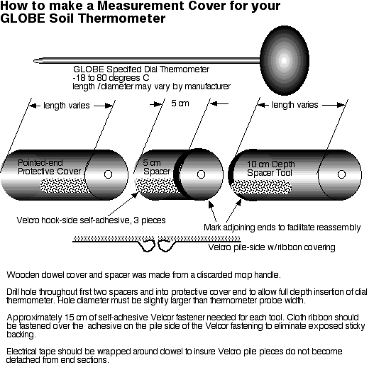
Suggested modifications to soil thermometer to enhance reliability
of measurements, prevent accidental injury, and protect the
thermometer from misuse. Drawing measurements may vary according to
the thermometer being used.
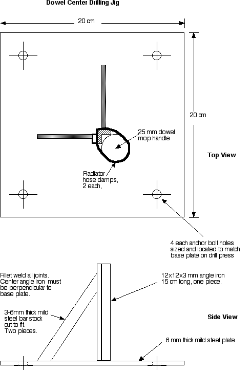
To allow for an exact drilling of a hole in
the center of the mop handle, one might fabricate a drill press jig
similar to this if no machinist vice or centering clamp is
available.
Last modified - 15 May 2011